On Dec 8 and 9, 2012, I attended a free workshop to introduce a GIS application called MapSAR to 40 attendees from several search and rescue teams throughout the state.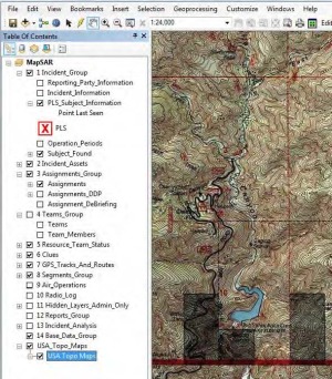
The MapSAR application is the result of collaboration between members of the Sierra Madre Search and Rescue Team, ESRI, Sequoia and Kings Canyon National Park, Yosemite National Park, Grand Canyon National Park, and the Mountaineer Rescue Group.
The goal of MapSAR is to bring GIS techniques and technologies to the Search and Rescue field. What is GIS? GIS as defined by ESRI is “A geographic information system (GIS) integrates hardware, software, and data for capturing, managing, analyzing, and displaying all forms of geographically referenced information.”
Click to read more ...

 Jeff Lehman