
NASAR/MRA Joint National Meeting
 Jeff Lehman
 I spent the first week in June taking a NASAR tracking class and attending the joint MRA/NASAR conference in Lake Tahoe. Between the rain, snow, and 70+ degree temps, it was a good conference. Here are some highlights.

The tracking class was great. It was a mix of classroom and field (both day and night) that culminated with a written exam and a large scale field exercise. I was afraid that it would be the same as the class offered in our county, but that was not the case. The principles are the same, but they went into a bit more detail with the management of multiple tracking teams, and with tracking in a variety of environments and times of day. I think that this was the second time that this class was offered, and the instructors were pulled from all over the country. It was good to get perspectives from different regions. Evidently it is part of a new tracking cert by NASAR. I was not aware of this prior to attending. I think it is a good class. It is a good "next step" from the county offerings. If anything it gives you more "dirt time" to hone your skills.

Vendor Exhibits
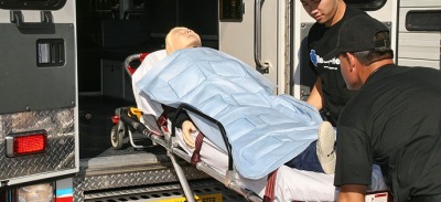
I spoke with a company that makes hypothermia kits for the military. The kits are a tarp, hood, blanket with heat packs in it, and other things. The kit itself is self-contained and costs a little over $100. That is pretty steep for something that is a single use item, but the blankets are intriguing. You can read about them at TechTrade. The one that I think that my team would be interested in lasts for 8-10 hours and costs about $38. They are shrink wrapped in heavy plastic.
There are a number of satellite tracking products out: Spot and InReach are the consumer versions that you may have heard about, but there are others. One product, TracPlus is particularly interesting because, for the most part, they are hardware agnostic. That is, they can display location data from a variety of sources. Much of the commercial tracking hardware is quite expensive ($900 per device), but they have battery live on the order of weeks, and are physically very robust. They all have some sort of two-way communication, that can be as simple as a few canned messages, or as detailed as an SMS message. The service plans are also suitable for SAR adoption since there are plans that only get activated when the device is turned on, which makes these devices suitable for caching.
Sarapp.com is a DARPA funded tracking app for iOS and Android that also integrates with Mission Manager. I tried it out at the conference and it is pretty good. It allows for users to see where they are relative to their assigned search area on a map, keeps track of things like estimated POD, and where other teams are. Of course this requires a smartphone with a data connection. This can be problematic in many wilderness areas, but I have found that smartphone apps that cache position data while out of coverage then send the data when a connection is re-established are very effective. After experimenting with these types of programs in wilderness environments, I have been amazed at how well they work. Even a brief moment of coverage will allow the sending of the cached data. I have been in areas where everytime I check my phone there is no coverage, yet the location data was sent. In my experience the big issues with using smartphones in the wilderness is battery life, and their "non-ruggedized" construction. I should get an admin account soon, and as soon as I do I will get more info out to you.
Decisions D4H was on hand to demonstrate their team management software. D4H has a comprehensive tool that allows teams to collect and analyze all sorts of team information. I have been watching them for a year or so, and they have produced a nice product. My only concern is cost. It would be a burden for a single team to bear the cost of such a tool, but I think that the county could benefit from such a platform. D4H has made some of their software free for states to collect SAR stats, so that may be helpful for getting things started. Speaking of stats... They are a big deal for justifying funding, so everybody is stressing the collection of stats. This is something that I, and many others, have tried to improve county-wide, and it seems that my frustrations are echoed in just about every jurisdiction across the country.
Meetings
From the NASAR general meeting. NASAR is restructuring its education program. They are going to rely on agencies having jurisdiction (AHJ) to vouch for their instructors. Evidently, in the past it has been difficult to become a NASAR instructor. This has been good for many of the instructors, since they make money by teaching classes, but NASAR believes that the change will allow more classes to be taught.
NASAR is contracting with an online association management firm. Among other services, this means that members will be able to download their certs rather than having to pay for additional copies. There was some concern that this would remove a revenue stream, but the thinking is that between the savings in office personnel and the higher volume of cert holders (more teachers), that the reduced processing fees will be made up.
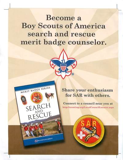
The Boy Scouts of America used the general session to announce a new search and rescue merit badge. The official release date is sometime in August, so all you merit badge counselors get ready.
From the MRA meeting. The national meeting for the MRA was on the day after the conference. One issue before the MRA is the proposed substitution of cave rescue for the snow and ice discipline. It seems that a team from the South East would like to seek full accreditation, but they never get enough snow to be able to train in such environments, nor do they get calls for snow/ice mssions. Cave rescue was discussed, but not voted on because the proposed bylaw changes were not distributed with enough lead time. It will be voted on in the January meeting. There are strong arguments on both sides of this issue. Roger Mortimer, Western Region Coordinator of the National Cave Rescue Commission, was there, so the NCRC weighed in. As I see it, the "pro" argument surrounds expanding the MRA, and the MRA becoming the de facto SAR team accrediting body in the US. Currently the MRA is the only national organization that accredits teams, so they are positioned appropriately. The "con" argument follows along the line that it is the "mountain" rescue association, and there are certain expectations of mountain rescue teams. The discussion is far from over.
San Bernardino Mountain SAR and Fresno County were two California teams voted in as associate members of the MRA. They are now cleared to pursue MRA accreditation.
Talks
High altitude medicine. I attended an interesting high altitude medicine talk by Ken Zafren of Stanford University and the Wilderness Medical Society. I have heard him speak before, and I have enjoyed his musings. This talk was about high-altitude medicine, and was geared toward practitioners, so some of the acronyms and vocabulary went past me. Here are a few highlights. It seems that the whole climb high, sleep low mantra works better the lower you sleep. Mountaineers are seeing strength increases if they descend to even lower elevations while acclimatizing. Don't take dexamethasone for more than 3 days. He was a professional witness at a trial where the climber was told to take "dex" at the first sign of altitude issues. The guy was on it for 30 days, and he is no longer 100% functional. There are two places in your body that initiate the altitude response. Somewhere in your lungs, and a place in a carotid structure in your neck. Between the two, they signal the changes that help you adapt. There are many things not understood with respect to humans' ability to acclimatize. There is something called hypoxic ventilatory response (HVR), and it seems that many people who acclimatize readily have a high HVR, but...sherpas don't. More mystery. Evidently physical conditioning, age, and gender have no affect on your ability to acclimatize. At extreme altitudes (above 5500 m) deterioration outstrips your ability to acclimatize.
The search for Air France Flight 447. Colleen Keller, an analyst for Metron Scientific, gave a great presentation on how her company was part of the search and recovery effort of Air France Flight 447 that disappeared in the middle of the Pacific Ocean en route to France from Brazil. There was little location information available, so extensive modelling was required in order to narrow the search area. Interestingly, the US Coast Guard and other similar organizations have pretty good models for how bodies drift in the ocean, but not big wind-gathering parts of aircraft. Often, buoys are dropped in the region of the wreck so as to get a measurement of currents and winds near the time of the wreck, but due to the location and other issues, this was not done, so there was little on-site info. Frankly because they didn't have a good idea of where "on-site" was. At about 4500 nm2, the search area was huge (about twice the area of the State of Delaware); it was important to search intelligently. Ms. Keller discussed the construction of their models, and the issues associated with such work. Nearly two years after the loss, the flight recorders were recovered, and a final report is due this year.
MapSar GIS. San Bernardino County's very own ESRI has been working on bringing GIS tools to the SAR world. Representatives of Sierra Madre SAR have been working with ESRI to build an application using ESRI's ARCGIS for use by rank and file SAR members. Traditionally, GIS tools are not as readily adapted to itinerant command post personnel. To realize the power of such tools, it takes a trained person who understands the software and data. With MapSAR, users are able to leverage the power of GIS datasets using a front-end that is well-adapted to the search manager. As soon as the manual is complete, the first public release of MapSAR will be posted. It will be free, but the user must purchase a copy of ARCGIS. Stay tuned for more information as it is available.
That's all folks....Drop me a line if you have any questions. I highly recommend that you get to a national meeting at least once. It is very important that we learn how other teams accomplish the same mission.
News
Reader Comments (1)
Thanks for the recap! I love reading how the conference went for folks. Great feedback on the tracking program as well.