GPS units supplement map and compass and oftentimes serve as the primary navigation means during search operations. For this reason, it's important to be proficient with your GPS device of choice. When it comes to choosing a GPS device you have 2 options; a dedicated GPS unit or using your Smartphone. For this article, we will be discussing the benefits of using your smartphone; specifically using Gaia GPS for its rich features, ease of use and availability on both the Android and IOS platforms.
Smartphone or Dedicated GPS?
Smartphones have the advantage in that they are a user-friendly option you are likely already familiar with. The controls and data input are much more intuitive when compared to the toggle keys on a dedicated GPS unit. Smartphones also offer a larger screen with a crisp visual display and cost significantly cheaper assuming you already own one.
The downside is they can be extremely power-hungry. To mitigate this, keep your phone in Airplane Mode and Low Power Mode (IOS) or Power Saving Mode (Android) and keep a portable power source in your 24hr pack. Check out this previous article on external battery options to keep your phone powered for an entire operational period.
Another downside is durability; dedicated GPS units are purpose-built to be rugged and most are waterproof to IPX7 standards or better. If you’re concerned about this, there are a number of rugged cases on the market from Otterbox and LifeProof that can increase the durability of your smartphone tremendously.
Another point to consider is that you'll have to download your maps ahead of time for offline use. However, this is easy to do and you can also customize the maps and layers to work with, which actually makes them much more beneficial than the standard maps that come preloaded on dedicated GPS units.
Gaia GPS Overview
With so many navigational options at our fingertips, let’s discuss some of the reasons why many SAR members have chosen to make Gaia GPS their GPS of choice.
You can use Gaia GPS for free, but you are limited to the default map source (Gaia Topo) and you can't download maps for offline use - making the free version not very SAR worthy. Many of the features discussed in this article require the premium membership, which is only $40 annually - a small price to pay when compared to the upfront cost of a dedicated GPS unit. The premium membership includes access to 250+ map sources across the globe that can be layered and made available for offline use. At a minimum, you need the basic membership for $20 annually, which allows you to download limited maps for offline use. A full comparison of plans and features is available here.
Customizing Gaia GPS
It’s easy to customize the visual display of the map so you can see relevant trip metrics like your current location, elevation, total time, distance, ascent and much more. You can also layer your preferred set of maps, grid overlay and choose to show or hide tracks, waypoints, labels or folders of grouped data. You can easily change your units of measure, coordinate type, datum and distance interval markers all within the settings area.
Downloading Maps for Offline Use
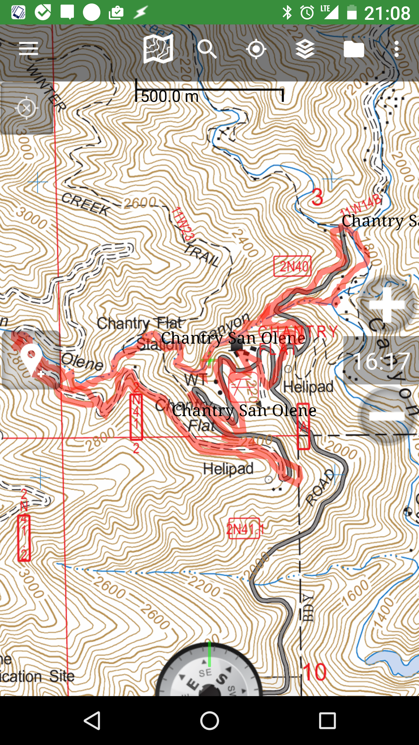
As mentioned, you need to download your maps for offline use prior to heading into the field. First, you need to decide which map sources are most valuable to you. My default view is the USGS Topo base map with Esri’s World Shaded Relief layer at about 25% as pictured here. I also like to have CalTopo’s Slope-Angle Shading layer downloaded for quick cross-country route analysis during missions.
To do this, make your preferred map sources visible on the main map, then choose the icon to download your maps and preferred layers. Save yourself time in the future by downloading the full mountain ranges you SAR frequent so you don’t have to think about it before heading out to a call. Map downloads are limited to 10,000 tiles and vary in size depending on your preferred zoom level, so you might need to download a few overlapping maps to get the full mountain range. Check these links for a full reference guide on how to download your maps on IOS or Android. Now let’s talk about some of the practical ways we can use Gaia GPS to aid in efficient search operations.
Search Assignments
Often times we show up to a mission and are presented with an area assignment to search.
Ideally, CP sends out the GPX files for area assignments ahead of time and you can easily import the GPX file directly to Gaia. You can do this by simply clicking on the attachment from the email and copying to Gaia. Check these links for a full reference guide on how to import GPX files to IOS or Android.
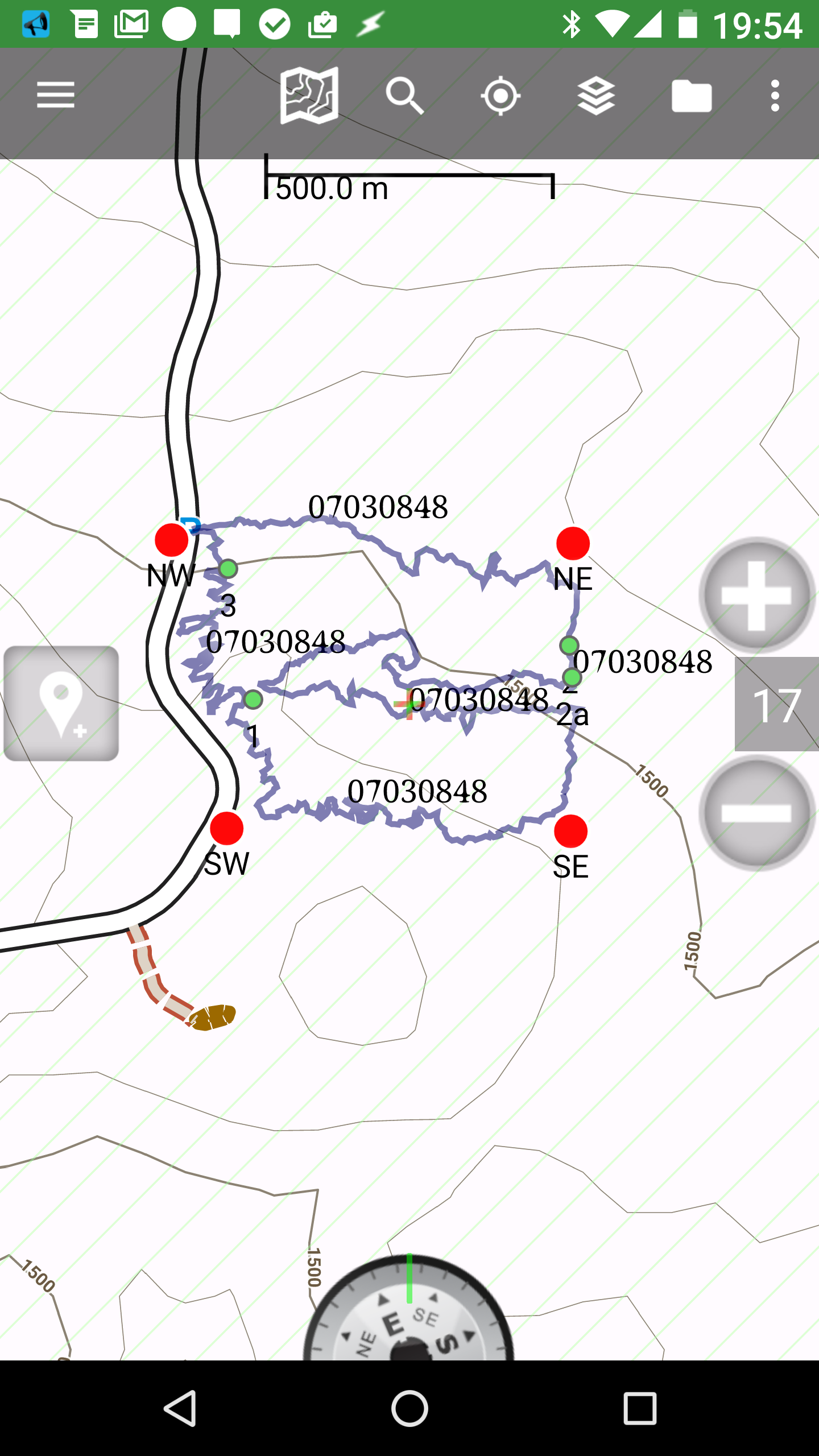
 If the search areas aren't available ahead of time, you’ll likely receive a paper map with your search assignment on it. If this is the case, you can create your own area within Gaia by either creating waypoints for the boundary lines or using visual references on the map to quickly create an area by dragging the area points by freehand.
During your search you may come across clues, areas of interest, tracks, visual disturbances etc. You can take pictures of these items in Gaia which will automatically create a waypoint with that photo. Alternatively you can create just a waypoint with details of the information to be relayed back to CP.
Mission Debriefs
When it comes to completing your mission, the most important part is relaying all pertinent details back to CP. The best way to do this is by exporting your entire GPX file (tracks, waypoints, photos, notes etc) and emailing the files to CP. The only way to export all related files is to assign everything to a singular folder and export that entire folder. If you only export a track, any waypoints or photos taken during that recording won't be included in that export. As a general rule, when showing up to a search create a folder for that days operational period first, then start recording. As you add waypoints or take photos during the recording, you can choose to save those items to the same folder. Once you save an item to a folder once - it becomes the default folder for the next item you save. This will make the export process and organization of data within the app much more streamlined. Check these links for a full reference guide on how to export your tracks on IOS or Android.
Creating a Historical Geospatial Database with Gaia
Having all related search files categorized by folders also makes future cross-referencing of your searches much more convenient and realistic. Imagine you are searching an area for a lost hiker and their PLS is in the general vicinity of a search you remember from a few years back. You can quickly access that previous search folder, see clues, tracks, lost person behavior and even chose to make the components of that folder visible on your main map and that might lead you to check an area that might have otherwise been overlooked.
You can include all relevant notes that don't have geospatial qualities such as POD, areas of interest, or maybe other items pertaining to your own mental debrief in the folder’s notes section. This keeps everything organized for future reference and you can copy/paste CP relevant notes when exporting your track to relay certain information back to CP. Currently there’s no way to automatically include notes on a file with the export, but this would be a great improvement for Gaia and SAR applicable! If you agree you can vote for this feature request here.
Guiding to a Location
 Let’s say you are in the field, and CP gives you a UTM location of a new PLS for the subject. Now you need to make your way to that location which involves a cross country route through difficult terrain. Create a waypoint for the location given, then choose “Save and Guide”. This gives you a straight line bearing from your current location to the new waypoint. You can see your bearing and distance to the new location and have a visual bearing line to reference as you begin your route.
If you have an internet connection you can create a route to a location using the snap-to-trail feature which also measures distances within the app. Check these links for a full reference guide on how to do this for IOS or Android.
Becoming Proficient Through Everyday Use
The best way to become proficient is through repeated use! If you're going into the wilderness for recreational adventures, don’t forget about Gaia! Play around with some of the features mentioned here and become proficient before you find yourself on a search.

If you’re using Gaia for recreational hikes, it's beneficial to keep all SAR related data in a separate folder and your personal hikes categorized elsewhere. Without a good organization method, your data can quickly get overwhelming and crowd your map. I find it best to organize all my personal data into folders by geographic regions and use a specific folder just for SAR, with subfolders by mission. The benefit is that you can choose to show or hide specific folders as to not overwhelm your map with data. I generally keep all folders hidden unless I want to reference them during a search or other recording.
These are just a few of the things you can do with Gaia GPS. For additional documentation on Gaia features and how to articles check out Gaia’s help section here
We will be holding a county course for those interested on Wednesday, Sept 4th from 1800 - 2030 so bring your questions! Message Jeff Lehman for more information.

 Sonny Lawrence