In the last installment, I discussed options for keeping your phone going throughout a SAR mission. Now, let's put it to work to keep you going in the right direction. Your smartphone is chockfull of a variety of sensors. It is probably the closest thing that we have to Dr. McCoy's "tricorder" from Star Trek. Aside from a GPS, most smartphones also have a compass, accelerometer, barometer, proximity detector, gyroscope, and light sensor. For land navigation the GPS, compass, gyroscope, and accelerometer are all used.
As SAR team members, our needs differ slightly from most recreational GPS users. For us, the typical GPS use case involves entering a number of waypoints and searching a particular area. Along the way, we will keep a tracklog of where we went, and mark clue locations or other waypoints along the way. For many, many years I longed for an inexpensive GPS with a simple numeric keypad. If you have ever had to enter a waypoint using the up/down/left/right keys on a typical GPS, then you know the tedium! GPSes are much better adapted to the recording of waypoints than they are for entering a remote location. Enter the smartphone. Now, we have a GPS platform that has a terrific keypad, where entering numbers and letters is a snap. Couple this with a fancy display, and voila! You can easily overlay your position on a map.
Before we go further, it is important to point out, that SAR team members need to have a GPS that can easily be configured for different map datums and coordinate systems. Sure, many maps are NAD83 or WGS84 nowadays, but there are still plenty in service that used NAD27. As such, we need the ability to move between at least these datums. Likewise, when using paper maps we use the UTM coordinate system, but when talking to air resources, we often need to use DM.M or DMS. Moreover, some e911 and CAD systems use decimal degrees (D.DD), so that is also handy. I was on a mutual aid search a few weeks ago where the coordinate system in use was MGRS, so that should be an option too. For me, any apps for land navigation must be coordinate system, and datum agile. This is what separates SAR-worthy apps, from those that are handy for tracking your mountain bike adventure or road race. One more thing...I am an Android user, and don't own an iOS device. As such, the apps mentioned below are Android apps that I have used on actual SAR missions. I suspect that there are iOS equivalents, so please let me know of your iOS favorites in the comments below.
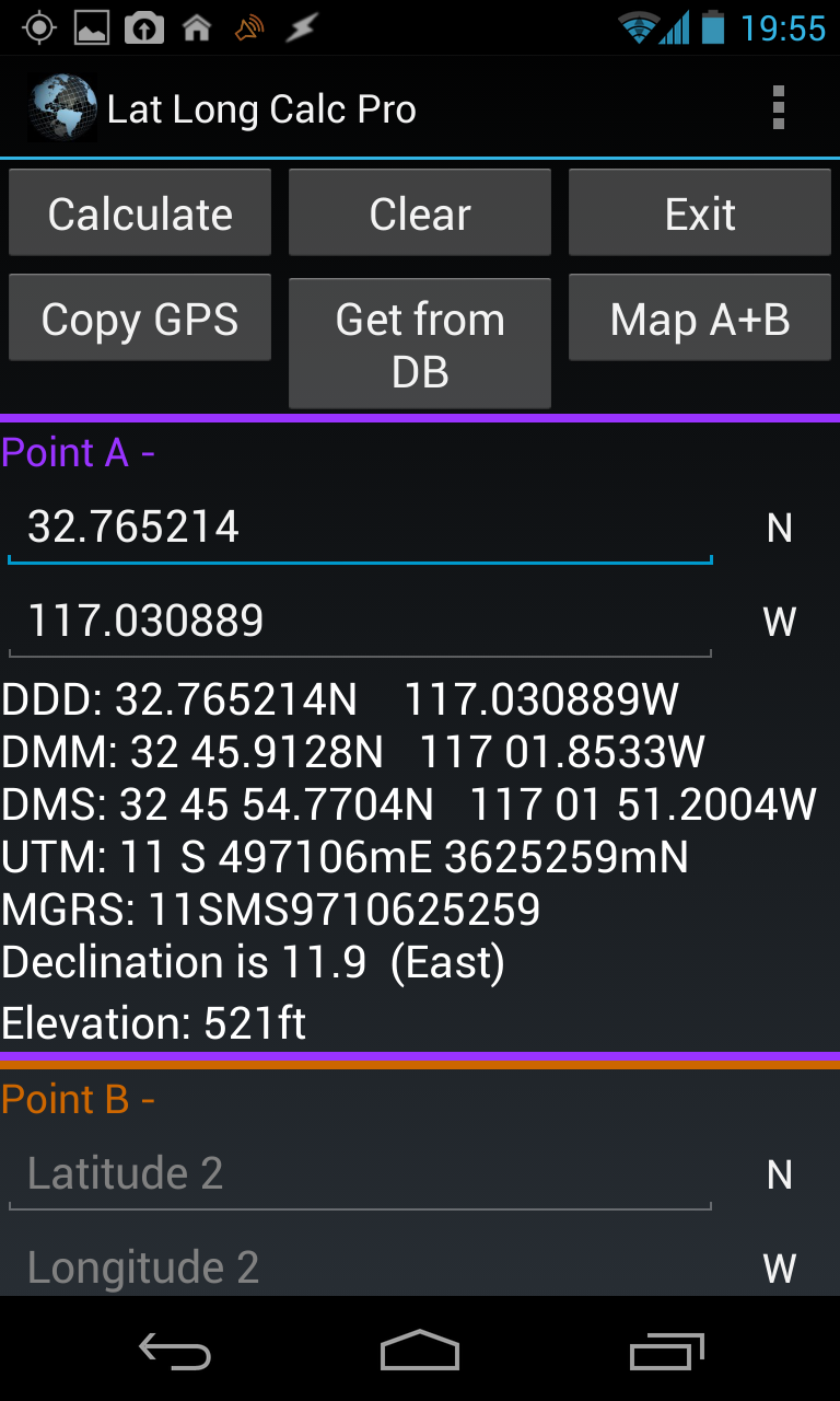 Lat Long Calc ProIf you are looking to record waypoints, and quickly convert locations to different datums and coordinate systems, then Lat Long Calc Pro is for you. You can simultaneously show your current location in a variety of formats, and you can use this tool to convert between formats and datums, store waypoints, "go to" a waypoint, and measure the distance between two waypoints. The pro version includes neat functionality that allows you to email or SMS your location to somebody, where it sends all the position formats in one shot as well as a link to your location on Google Maps. The only criticism that I have is that the user interface can take a while to master. The "pro" version costs $1.99, but there is a free version that maintains most of the functionality. As a rule, I always prefer purchasing the pro versions of software so that I can help support the developers of such cool tools.
SAR missions occur mostly in wilderness areas. This means that for a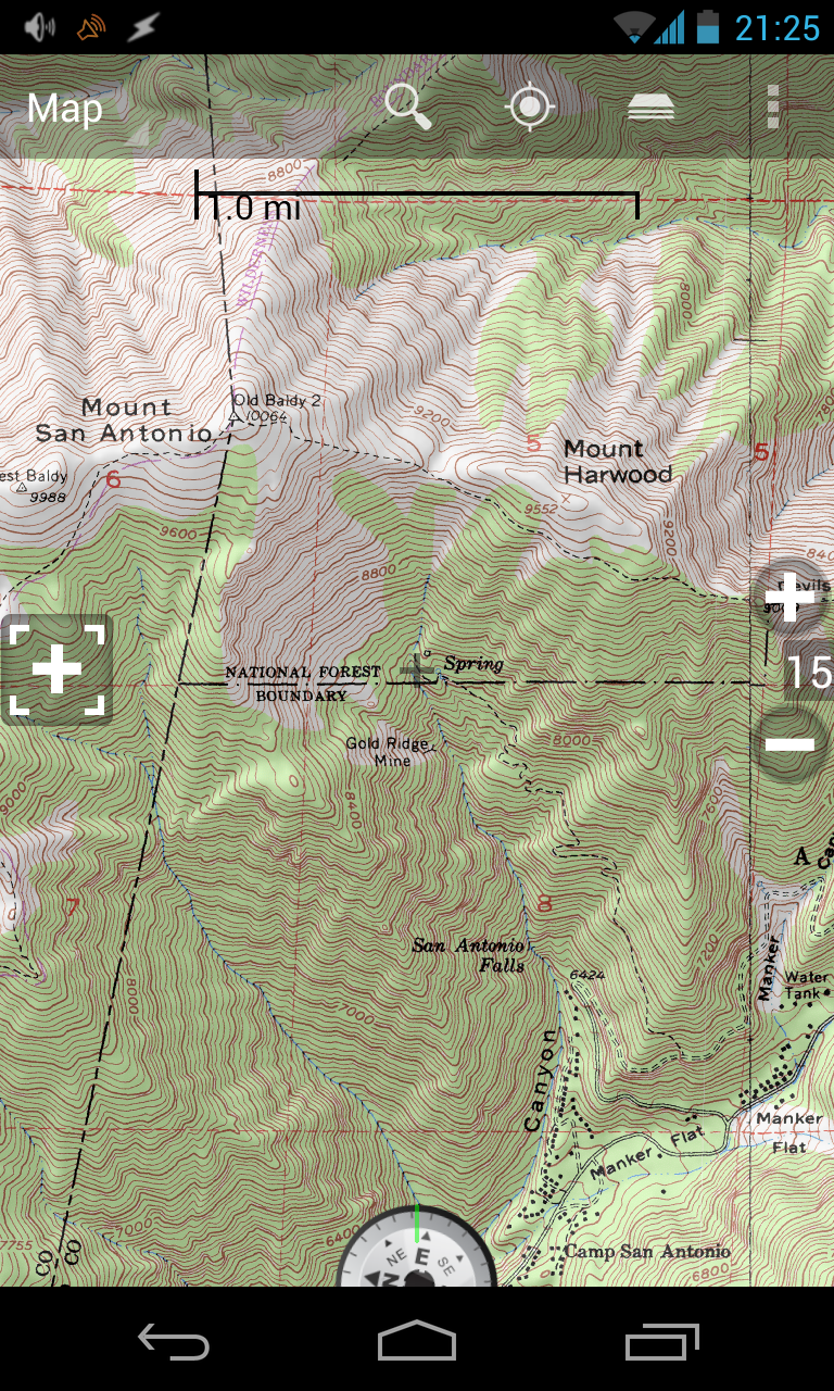 Backcountry Navigator tool to be useful under all conditions, it should be able to be used without a data connection. Currently, Backcountry Navigator is my favorite land navigation app. This tool has all of the features of a typical GPS and allows for offline topo map use. Also, you can export your GPS tracks to .gpx or .kml format, so that you can give them to the command post and/or import them into Google Maps. This tool allows for switching between WGS84 (same as NAD83) and NAD27. Also, waypoints can be quickly entered and viewed in a variety of formats without having to hunt through settings. Aerial photography is also available for download, which can often be handy for finding landmarks not shown on a typical USGS topo map. Backcountry Navigator also has the ability to import additional, premium, map sources for additional cost. While not free,
 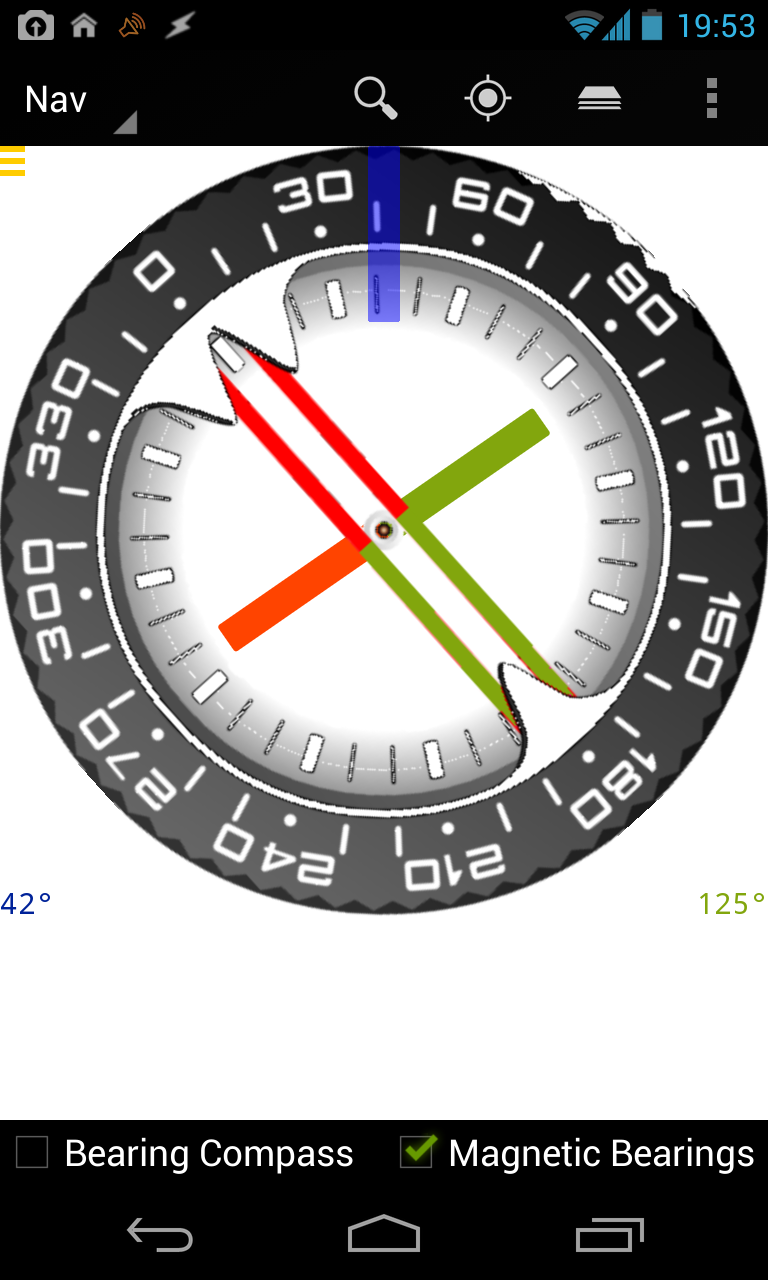 this app is well worth the price.
I have found many of the compass apps to be more novelty than tool, but this is not the case with the compass that is available in Backcountry Navigator. It is a completely, field-worthy compass that I have used to complete a BSAR Skills check-off on a couple of occasions. It functions the same way as your typical orienteering compass, and with proper calibration, yields similar results.
Other mapping/navigation apps with similar functionality that I have used are Trimble Outdoor Navigator and MyTrails.
Finally, I wanted to take a second to mention a tool that I use regularly in rope rescue operations: a pocket theodolite. A theodolite is a device that is used to measure horizontal and vertical angles. When you couple this with a camera, compass, and GPS, you have an interesting tool. I mention it here due to its compass and GPS features, but I find it is most useful as an inclinometer. In rope rescue, determining the angle of a slope is important when it comes to calculating loads on your anchors and equipment. GeoCam is a tool that makes the measurement of slope angle very easy. Using the camera as a "viewfinder", you aim the phone at an appropriate landmark, and your vertical angle is measured. You can also get a compass heading, and GPS location at the same time. Check out the image below that I took during a recent litter evacuation.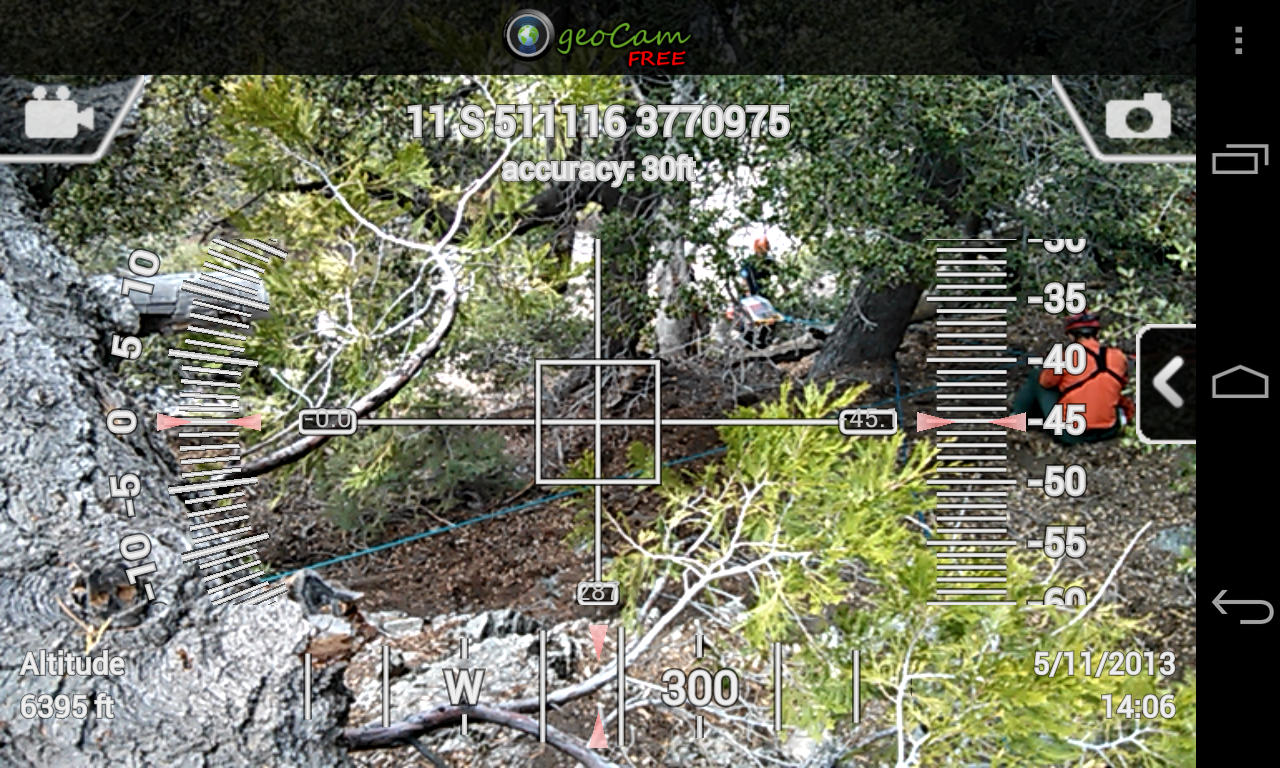 GeoCam
Sorry about being so Android-specific, but this is the only platform with which I have direct field experience. Please let me know your favorite iOS apps in the comments.
Stay tuned for the next installment where we will discuss apps useful to the incident manager.

 Jeff Lehman
 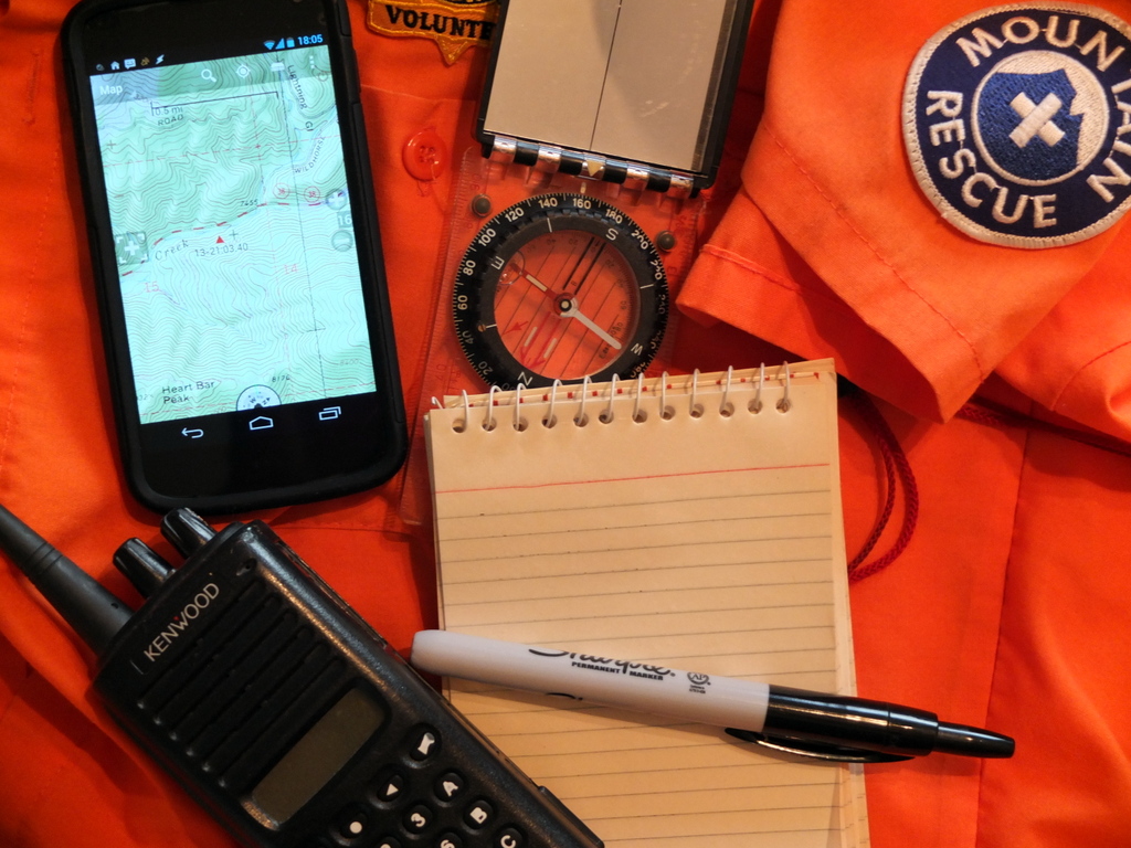 Good communication is key to a successful SAR mission and team administration. As SAR team members we are used to getting calls in the middle of the night, and making last-minute plans. It is the way things go in the SAR world. For effective, timely communication we must use multiple channels. These are often email, pager/SMS messages, phone, and radio. Traditionally radios have been the sole source of communication in the field, but with the increased cell coverage in many areas, the cell phone is becoming a useful tool for tactical communication as well.
  The tool is called Celly, and it does exactly what I have been looking for.