Day One
View The Search for Donald Foster in a larger map
A Missing Person report was taken for Mr. Foster on 9 June 2010. A SAR Hasty Team was deployed from the Joshua Tree station at noon Friday 11 June. Six members of the Morongo Basin SAR team were deployed to the location of Mr. Foster’s vehicle. Mr. Foster’s family, who had previously located his vehicle, had completely obliterated any of Mr. Foster’s potential footprints around the vehicle. Dep.Mary Lee Brown located one partial print on the inside bottom of the driver’s door. The team used that partial print in the attempt to find Mr. Foster’s track. The wind had been blowing steadily for several days prior to the callout. The team performed an expanding perimeter search around the vehicle, attempting to locate Mr. Foster’s track. A set of prints was found, corresponding to the information the family provided as to the type of shoe Mr. Foster was wearing, heading away from the vehicle in a south easterly direction. The tracking was extremely difficult, due to track age, weather conditions and the sun was directly overhead. It took the team over three hours to track approximately 400’, when the track was lost. Later this track proved to belong to a family member. The decision was made for a County Wide Callout.
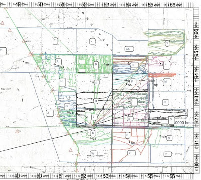
We staged our C.P. at the Landers Elementary School. Additional resources, primarily Jeep were deployed for the remainder of the day’s efforts. The C.P. began the planning for the next day’s operation. A grid was developed (see Day Two map) for team assignments. In addition the Team Assignment form “boiler plate” was filled in with DR number, communication frequencies, etc. All that remained was to add the names of the individual team members.
 |
| From Foster Search June 2010 |
Day Two
The turnout for this day’s operation was terrific! We had 51 personnel from the various teams in the county. Every effort was made to deploy the teams as quickly as possible after they received their briefing. The Team Briefing sheets were done, sans team members, when the C.P. staged at 0600. There were three signup sheets, one for each resource type, Ground, Mounted and Quad. This made allocating the resources much easier. We had to guess on a significant number of the names. When signing in, PLEASE PRINT YOUR NAME SO IT CAN BE READ!
The Team Briefing sheets each had an attached map, indicating the team’s assigned area and a photo of Mr. Foster. The teams were briefed to talk to the local area residents, if available, to see if they had seen Mr. Foster. The importance of GPS was stressed. The team’s were reminded to clear the Track Log at the briefing as well as when they checked in when starting their search in the assigned area. The “Top of the Hour” check-in was used.
 |
| From Foster Search June 2010 |
The logistics were great. The Landers Elementary school opened their facility for our use. This was greatly appreciated by all the teams. The Joshua Tree station provided the food, as well as anything else that was needed.
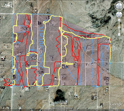
When one team completed an assignment and there was time and they were willing (and they all were), their GPS was downloaded. Their track was examined to look at the area covered, and then they were given a new assignment.
As each team returned to the C.P., all the GPSs in that team were downloaded. This was a time consuming effort, but well worth it. As you can see from the attached maps, the downloaded information made the next assignments easier, more importantly, seeing the actual coverage of the assigned area was a major benefit.
 |
| From Foster Search June 2010 |
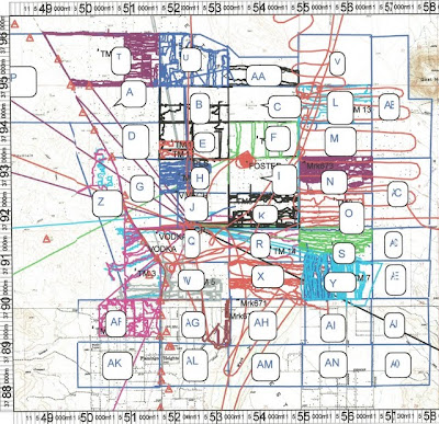
In the afternoon of Day Two the planning for the next ops period began. Additional areas were allocated, (see Day Three map) and the Team Briefing sheets prepared. Always prepare more briefing sheets than you think you will need. It saves time should additional resources show up.
Day Three
The turnout for this day’s operation was again outstanding! We had 81 personnel sign in. The sign-in for Day Three started at 0630. Once sign in was completed, team assignments were made, the briefing completed, the teams’ were deployed.
As soon as lunch was completed, we started planning for Day Four. The decision had been made to continue the search through Tuesday 15 June.
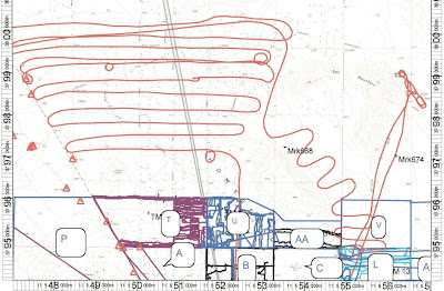
The support from 40 King was outstanding. On this day we gave 40 King one of our GPS units. We turned it on, cleared the track log, and so all they had to do was take it for a ride. We downloaded the unit upon their return. You can see the results of their first hop on the “Helo” map below. We would like to make this a standard operating procedure, if possible, when 40 King is providing support. We asked them on their next hop to give the GPS another “ride”. That result is on the Day Two map.
 |
| From Foster Search June 2010 |
At approximately 1800 40 King located Mr. Foster. You can see the 40 King “hover” over the victim on the Day Three map. We had an address and we plugged it into our mapping program for a location. It identified a position, which had the correct street but incorrect location on that street. So the mapping program’s capability in this regard will get you in the ball park, but not the right seat!
Mr. Foster was deceased. He was located adjacent to a fence line between some heavy foliage and the fence. You would have had to pass relatively close to him before you would have seen him. The coroner estimated time of death was the previous Thursday evening or Friday morning.
The personnel coordinating the search effort thanks all the SAR personnel participating in the operation. Enough cannot be said about the dedication, professionalism and cooperation of all the County’s SAR teams.